What can meandering rivers tell us about the climate change?
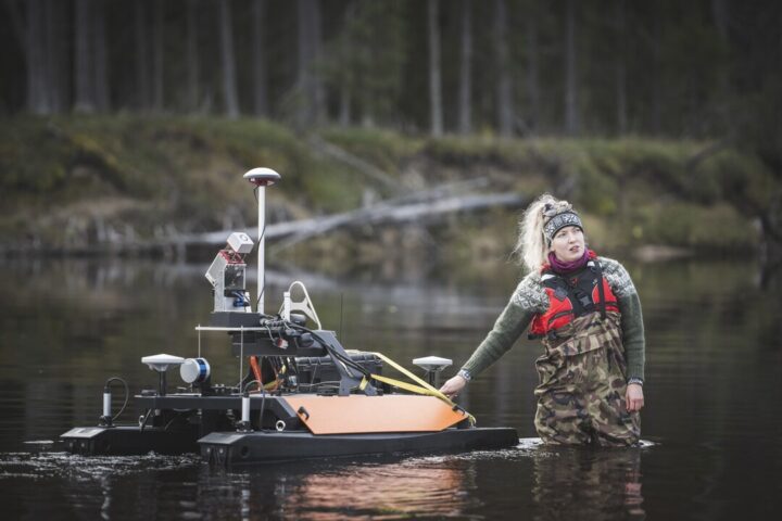
Linnea Blåfield is a fourth-year PhD student in the University of Turku, conducting research mainly at rivers Oulanka and Pulmanki since 2020. Her main focus is the sediments of the meandering rivers – how it moves and how the meandering river environment changes based on the sedimentary processes. The research team of the new publications and her PhD supervisors are distributed across the Freshwater Competence Centre partners Finnish Geospatial Research Institute FGI and University of Oulu, as well as her home base, University of Turku.
Text: Annukka Pekkarinen & Linnea Blåfield, Image: Ville Kankare
Firstly, we asked Linnea to explain why meandering rivers, what is fascinating about them?
“One can see the geomorphological changes of meandering river environment relatively fast compared to some other river types, as they are constantly on the move, changing position and form and the landscape. Flowing water and the rivers are fascinating because one can see, even with their bare eyes how the environment changes, how the sand moves, how a bank that used to be sand is gravel this year – the changes are so concrete!” Linnea explains.
The first publication is a year-long morphodynamic modeling of the river Pulmanki where the aim was to define certain threshold discharges for levels of sediment connectivity. Linnea & the research team measured flow dynamics, sediment grain size and the geometry of the river bottom and the banks in the autumn and returned one year later to do the same measurements to see what had changed. There had for example been 7 months of ice cover and one bigger flood during the year. With the morphodynamic model the scientists can estimate when the observed, measured changes have possibly happened and how well the model reflects the real-life conditions in the nature.
Where does the sediment go in one year?
What is interesting to Linnea, is to know what kind of flow and which seasonal hydrological events get the sediment moving, where it comes from and where it ends up aka “sediment connectivity”. When she knows the source of the sediment and where it was deposited during one year, the model can give insight into all those spatio-temporal processes that happen in between. The model could be even run by one-hour intervals but it’s relatively heavy computing due to high spatial resolution, so Linnea was modeling weekly changes.
Spring flood and the following ~2-month period of moderate flow causes biggest morphological change but some changes happens also outside of this period, during late autumn and winter. Now that we know how the sediment connectivity functions at present, we can start evaluating possible future scenarios.
Linnea is dreaming to have a sand laboratory – a hall full of sand where one could try various flow angles and materials, and how they react when you release a flow of water through. “That would be super cool to have!” she says. Aalto university has a flume where they can test certain flow impacts and in UK there are larger ones, where they can even change the temperature of the laboratory to test winter conditions.
And what did she find out?
Linnea’s second Oulanka paper goes further than just one year. She examines a 50-year time series of geomorphologicand hydroclimatic data from the area. She wants to know if some hydroclimatic changes have occurred – and can she already see the impacts in the sediment transport.

“Even if I know that climate change is happening particularly in wintertime Finland, but the results really made it concrete to me. The average temperature of December had increased 7 degrees in 50 years, and annual mean temperature 3 degreees. That is just ludicrous.”
There have been also notable changes in the hydrological conditions. There has been a decrease in the impact of snow melt driven spring floods on sediment transport, but the precipitation driven flood events of summer and autumn increased with the more intense rainfall. Thus, we are transferring from snow dominated hydrological regime to precipitation dominated. This is something that has been forecasted for a while already, but now we can measure it in the field, see the change in the sediments and the water, Linnea explains. Particularly between 1994-2005 – over 70% of the notable hydroclimatic shifts happened in this window of just 10 years. Erosion and transport rates did not change significantly during the observed time-serie, but due to shifts in peak discharge timing, we can see changes in the seasonality of sediment transport.
And why is this important to know? “The flowing water carries sediments and nutrients. If the factors that control this flow change drastically, there could be considerable changes especially in the lower parts of the rivers, regarding sedimentation, nutrient conditions, water quality, ecology and therefore the whole landscape.” Linnea explains. Next step is to model different climate change scenarios on sediment connectivity in high latitude areas.
If we know what may happen, we have better chances to prepare for the upcoming changes. Freshwater Competence Centre, particularly the European Union – NextGenerationEU-funded research project Green-Digi-Basin and infrastructure Hydro-RI-Platform and Hydro RDI network, as well as the Digital Waters Flagship, are aiming to provide our society and decision-makers exactly that type of knowledge.
www.freshwatercompetencecentre.com, www.digitalwaters.fi
Related articles:
Linnea Blåfield, Hannu Marttila, Elina Kasvi, Petteri Alho, Temporal shift of hydroclimatic regime and its influence on migration of a high latitude meandering river, Journal of Hydrology, Volume 633,2024 https://doi.org/10.1016/j.jhydrol.2024.130935.
Blåfield, Linnea and Calle, Mikel and Kasvi, Elina and Alho, Petteri, Modelling Seasonal Variation of Sediment Connectivity and its Interplay with River Forms. Pre print Available at http://dx.doi.org/10.2139/ssrn.4828535


